The Smith Train Massacre Site
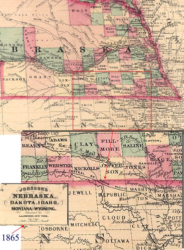
This 1865 map fragment shows the features of northern Kansas which figure in the documents comprising Wesley C Smith’s manuscript on the Smith Train massacre, as it hurried to catch up with the Fancher, an even more ill-fated wagon train, being completely wiped out by Mormons and Indians at the infamous Mountain Meadows Massacre about three months after the Smith Train attack.
Notice the trail marked (above the “A” in “[NE]BRASKA”) “Lieut. Warren 1855”. It joins the Republican Fork of the Kansas River about 40 miles north of Ft Riley, Kansas, and then proceeds to follow the Republican north another 40 miles to about the Nebraska border before parting with it to head toward Ft Kearney, Nebraska, by joining with and then following the Little Blue River. This is the very road referred to several places in the Smith manuscript. It disagrees in name attributed (Lt Col Francis Bryan in one place, Lt Bryan in another) but not year with the map. The trail south of Ft Kearney might well have been laid out by a different man than the trail north, so this is not necessarily a contradiction. The Smith Train was on this trail when attacked at the point where it parted from the Republican.
O’Fallons Bluff can be found under the “B” of “[NE]BRASKA” on the map. This was the location of the Fancher Train on 11 June 1857, according to the manuscript, shortly after the Smith Train massacre on 6 June 1857.
Republic Co of KS is the site of the Smith Train massacre, and Cloud Co, to the south of Republic Co, is where several of its survivors were subsequently found. The topmost red arrow points to the site, just below the Nebraska border (just below the "N" in "UNION").